Sylvan Trail
Cleveland MetroparksNorth Chagrin Reservation
Location
Mayfield Heights, Ohio (Cuyahoga County)
From Interstate 90, head south on State Route 91 (SOM Center Road). After crossing State Route 6, North Chagrin Reservation is accessible at Strawberry Lane, on the east side of Route 91. Take Strawberry Lane until it ends at Buttermilk Falls Parkway. Head South (right) on Buttermilk Falls Parkway and take it until it dead ends at Forest Picnic Area. The trail starts at an information kiosk at the far eastern side of the clearing and parking lot.
Summary
Length: 1.25 Miles
Duration: 1 hour
Surface: Gravel/natural
Type: Loop
Difficulty: Easy to moderate
Accessibility: No
Description
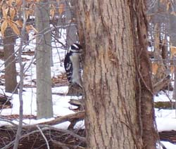
A male downy woodpecker feeding along the Sylvan Trail. The patch of red on the bird's head is the clue that tells it is a male.
Starting from the AB Williams Memorial Woods trailhead at Forest Picnic Area, the Sylvan Loop trail heads into a mixed forest consisting of Shagbark Hickory, Red Maple, White Ash, Sugar Maple and young to moderately aged Beech. You will notice many Black-capped Chickadees. The trail meanders through an area of younger woods with dense understory growth.
There are many wet spots along the trail, where pond or water sits. These small wet areas are known as vernal pools. They're very important to the ecology of a woodland system like the Beech-Maple forest that the trail is now meandering into. About 200 feet up the trail, you notice that the beech trees become much more numerous and some of the other species fade out.
About 900 feet in, there is a large opening in the canopy where a number of trees have fallen providing light to the surface. In this area the vernal pools are more vegetated and you'll notice plants like cattail and wool grass, which are both wetland plants. About 1500 feet in on the trail, you'll cross the North Chagrin Bridle Trail and the Buckeye Trail. Another 75 feet, brings you to a wooden bench in a peaceful spot along the trail. The overstory of the forest is dominated by a mix of Tulip trees, Sugar Maples, Red Maples, and American Beech in this area. About 1800 feet in, you reach the point where the trail becomes a loop trail.
Follow the right leg of the trail. Near here is the intersection of the Overlook Trail and the Castle Valley trail. At about 2100 feet, the trail skirts the edge of a deep Hemlock-lined ravine. A small headwater stream and shale bedrock is visible at certain points through the vegetation. You'll notice Christmas Ferns lining the ground in the ravine. You may notice Black Gum and Cucumber Magnolia trees in this area as well. At about the half mile mark, the trail follows the edge of the ravine to the left. You find yourself in a spectacular grove of hemlocks mixed with assorted hardwoods, including Cucumber Magnolia, Red Oak, Beech and Maple. From this point, in the winter time, there is a spectacular view across the Chagrin River valley. A large marsh complex sits below the edge of the ravine in this area, which is great waterfowl habitat.
A little further down the trail, there are wooden stairs embedded in the surface to help hikers ascend a slight incline. In this area overlooking the wetlands complex, at the bottom of the slope, Red headed woodpeckers are frequently seen, while the large number of down trees provide great foraging resources for the Pileated woodpecker. Soon, the trail takes a slight up-hill incline and follows another ravine on the right. At about the 4000 foot mark, you will come to a small opening in the canopy on the left-hand side of the trail.
Here, grape vines have pulled down a canopy tree in the past, allowing sunlight to penetrate the usually dim forest. Now young growth is starting from the forest floor. You can see the circle of grapevines all the way around the opening. As hiking the trail in this area, you'll notice a number of down trees that were uprooted. Pits where the roots were once firmly embedded in the soil and mounds where the soil piled up when the tree was uprooted create a series of hummocks and depressions, known as pit and mound topography. These pit and mound complexes are one sign of an old growth forest because it shows that the ground has not been disturbed for a very long time. This forest is not yet considered old growth, but given time, it will be. A wooden bench marks the point where this leg of the trail meets the entrance loop where we first started.
Nearby Trails
Castle Valley Trail
Overlook Trail
North Chagrin All Purpose Trail
Buckeye Trail
North Chagrin Bridle Trails