Ohio and Erie Canal Towpath Trail
National Park ServiceCuyahoga Valley National Park
Location
Between Independence and Akron, Ohio (Summit and Cuyahoga Counties)
Park at any of the Towpath Trail parking lots within Cuyahoga Valley National Park. These include:
Lock 39 Trailhead, Rockside Road in Independence, just west of Canal Road.
Canal Visitor Center, Hillside Road, just west of Canal Road.
Station Road Parking Lot, Riverview Road in Brecksville, just south of Rt. 82.
Red Lock, Highland Road east of Boyden Road, west of Riverview Road.
Boston Trailhead, Boston Mills Road, just east of the Cuyahoga River, west of Hines Hill Road
Lock 29 Trailhead, off Akron-Peninsula Road, north of route 303 in Peninsula
Hunt Farm, Bolanz Road, midway between Riverview and Akron-Peninsula Roads
Ira Trailhead, Riverview Road, just north of Ira Road
Botzum Trailhead, Riverview Road, just south of Bath Road
Summary
Length: 22 miles
Lock 39 to Canal Visitor Center 1.75 miles
Canal Visitor Center to Station Road 4.5 miles
Station Road Parking Lot to Red Lock 2.5 miles
Red Lock to Boston Trailhead 1.75 miles
Boston Trailhead to Lock 29 Trailhead 2.5 miles
Lock 29 Trailhead to Hunt Farm 3 miles
Hunt Farm to Ira Trailhead 1.75 miles
Ira Trailhead to Botzum Trailhead 1.75 miles
Duration: 8 hours
Surface: crushed limestone
Type: hike or bike in and back on same trail or park cars at each end of a segment and hike from one car to the other
Difficulty: Easy
Accessibility: most of the trail is handicap accessible
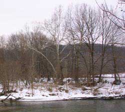
Sycamore Trees along the banks of the Cuyahoga River at Stumpy Basin.
Description
Beginning at Lock 39 Trailhead and heading south, you will quickly get a feel for this pastoral valley, a remnant living landscape preserved from development by the National Park Service. You will be hiking along the Ohio and Erie Canal, which was the economic backbone of the region's development through much of the 19th century. You will see the remains of the canal, which is watered from Route 82 north, along with locks, one of which is still functional (scheduled demonstrations are held at Canal Vistor Center). You will hike past farm fields, both actively farmed and in various stages of succession following abandonment. The NPS is working to revitalize farming in the valley, so chances are many of these disused fields, which currently provide valuable wildlife habitat, will be returned to agricultural production within the next 10 years.
The trail, which lies generally on the alignment of the old towpath used to pull the boats along the canal, runs along these fields and into woods here and there. The forests along the trail are almost exclusively floodplain forests dominated by huge sycamores (Platanus occidentalis) and cottonwood trees (populus deltoides), and sprinkled with an ample sampling of Ohio Buckeye (Aesculus glabra), boxelder (Acer negundo), and silver maple (Acer saccharinum). This riparian forest is a pretty good indication that the Cuyahoga River is never far away.
The river winds through the valley, shifting its course frequently. You will see signs of this movement as you hike. Such signs include old oxbows which develop into emergent wetlands with cat-tails (Typha latifolia), sedges (Carex spp.), willows (Salix spp.), and a variety of other wetland plants. You may also see rows of trees lined up on berms a good distance from the river, with a low peninsula between the river and the larger trees. The picture to the right is an example of such a situation. The sycamores, known by their bright white coloration on the upper branches and trunk, sit on a berm which was previously a riverbank.
Along the banks of the river, you will see the bamboo-like stalks of Japanese knotweed (Polygonum cuspidatum) which colonizes bare areas in its native Asia. In northeast Ohio, the plant is considered invasive and is spreading rapidly in riparian areas such as those you will be hiking through.
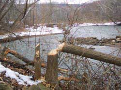
A tree felled by beaver along the Cuyahoga River in Cuyahoga Valley National Park in northeast Ohio.
Wildlife signs abound along the trail. White-tailed deer are common in the valley, as are beaver. Nature's engineers, beaver were once rare in Ohio. Now, they have made a comeback.
They are restarting the ancient cycles which helped to keep these riparian habitats dynamic and diverse. First, beaver will dam a stream and girdle many of the trees. They build lodges and create food caches for winter. Over time, as the food sources from trees and shrubs become more scarce, nature provides by an increase in wetland plants such as pond lilies and cat-tails which the beaver may use as food during winter.
After several or many years of occupancy, a beaver marsh may become less suitable for beaver, so they move on to a new site to begin their work again. Then, the original dams begin to leak and break down. This lets much of the water out of the wetland, and sets the scene for a young meadow to develop. Over many years, this may develop once more into a forest. At any time, beaver could reappear to stop the cycle and revert the area to marsh. This constant renewal and abandonment is believed to have occurred cyclically for time untold in these bottomland areas. You may see a currently occupied beaver lodge, and observe first hand their dam building skills at the Ira Road beaver marsh, just north of Ira Trailhead.
Special Rules
Keep dogs on leash at all times. Be aware that the trail is used extensively by bicyclists, so stay to the right, and listen for audible signals such as bells to indicate you are being passed by a bicycle.
Nearby Trails
Just a small sampling of the 125 miles of trails within Cuyahoga Valley National Park have been reviewed here. Try them. You will not be disappointed.- Boston Run Trail
- Buckeye Trail, Pine Lane to Boston Mills
- Ledges Trail
- Haskell Run Trail
- Tree Farm Trail