Overlook Trail
Highbanks Metro Park
Columbus Metro Parks
Trail Location
Lewis Center, Franklin County
Access Highbanks Metro Park from Route 23. From I-270, take U.S. 23 north 3 miles. The entrance is on the left. If you get to Powell Road, you have gone too far.
Trail Summary
Length: 2.6 Miles
Duration: 2 hours
Surface: natural
Type: Loop Trail-Hiking,
Difficulty: moderate
Accessibility: The trail is not ADA accessible.
Trail Description
Access the Overlook Trail from the Dripping Rock Trail near Oak Coves Picnic Area. This moderately difficult hiking trail traverses several different forest stands, as well as an old-field habitat.
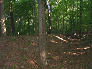
A view of the ancient embankment and mote created by indians, possibly to defend a village from attack by hostile neighbors.
As you walk this path at Highbanks Metro Park, you will mostly be hiking through a beautiful oak forest, with fairly sparse groundcover. The plants that grow here can survive under low-light conditions, and can push their way through the thick leaf-litter that is common in oak woods.
You will pass into an area dominated by American Beech and maples. Here you will notice that the forest has less leaf litter, has a bit more soil moisture, and more plants growing on the ground.
At the furthest extent of the loop trail, a spur takes you to an overlook deck which provides views of the Olentangy River, which is designated a "Scenic" river by the State of Ohio for its natural beauty and relatively natural condition. From the overlook, you gaze down on a floodplain dominated by Sycamore trees, growing along the river some 110 feet below. The high shale walls below the overlook gave rise to the name of Highbanks Metro Park. In the distance you can catch glimpses of State Route 315, as well as some commercial development and disturbed land. The view is a good reminder of what we humans may do to scenic, aesthetic resources if given the time, money and ability.
On the way into the overlook deck, notice as you pass by a depression followed by a berm. This feature is an ancient fortification, which probably protected and Indian village at one time. The fortifications are more than a quarter mile long, and terminate at the steep cliffs above the Olentangy on one end, and at a series of steep ravines on the other, thus providing good protection to the people who once lived here.
As you walk back along the return leg of the trail, it is easy to imagine that this landscape probably provided everything people living here in ancient times needed. There is abundant game, with squirrels, deer, rabbits, and other wildlife habitat all around. The Olentangy provided a good source of clean drinking water at the time, and there was plenty of raw materials from which to form shelter. This trail is a great place to contemplate how little it really takes for us humans to be healthy and happy, and conversely, how much we have that keeps us from realizing that we can be healthy and happy with much less.
Nearby Trails
Big Meadows Path
Coyote Run Trail
Scenic River Trail
Dripping Rock Trail