Rising Valley Park Trails
Rising Valley ParkOperated by
Richfield Township
and Hinckley Township
Trail Location
Richfield and Hinckley Townships (Summit & Medina Counties)
Access Rising Valley Park from Oviatt Road from State Route 303 near the Medina/Summit County line.
Trail Summary
Length: about 1.5 miles
Duration: One to two Hours
Surface: natural
Type: Loop.
Difficulty: moderate
Accessibility: no, steep slopes, some uneven surfaces.
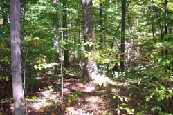
Just off the trail to the left as you ascend back toward the developed portion of the park is this nice oak hickory forest.
Trail Description
The hiking trails in Rising Valley park are unmarked, and the mileage indicated is approximate because of the lack of information provided. You can access the trails by parking near the north end of the ball fields, near the picnic pavillion, and heading west along a grassy lane. After passing through a gate, the trail heads downhill. The trail is wide, which allows for many light-loving plants to thrive along the trail. As you walk this portion of the trail, in the fall you will see the beautiful purple New England Aster, as well as a variety of white asters. Down the trail a bit, begin looking into the woods to your left. at the bottom of the hill there is a wetland which provides the opportunity to look at wetland plant and animal species such as elm trees,burr reed, and perhaps wood ducks if you are lucky.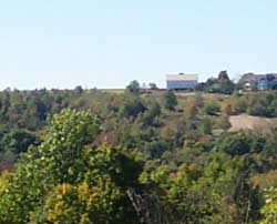
This long view across the valley of the Rocky River's east branch is a good example of the rural landscape of Hinckley and Richfield.
The trail splits in this area, allowing you to explore the bottomland area by veering right, or continue around the loop back to the parking lot by staying to the left. Either way you will get glimpses of some fairly natural, pleasant forests as you trapse along the hiking trail.
As you begin to climb back up to the developed area of the park, the trail narrows just a bit. This small change alters the feel of the trail and creates a more natural light environment for the plants that typically thrive in the shade of the forest. Because of this, it is easier to see into the forest for this section of the hike.
As you continue, you will see a number of small ravines or gullies which flow through the forest and eventually join the east branch of the Rocky River. The water from these streams and hundreds like them is what eventually determines the quality of water flowing into Lake Erie. By providing natural filtration, woods and wetlands like those in this park provide vital public functions beyond recreation. In a very real way, natural habitats help to keep our water clean.
These woods also provide habitat for songbirds and other wildlife. As you hike up the hill, you will come to a small clearing with a large dead tree standing in stark contrast to the blue sky above. Look at the bare tree standing there and you will notice a number of small holes. Woodpeckers feast on the insects that infest dead and dying trees. This one is no exception. By allowing this tree to naturally deteriorate rather than removing it, the managers of this park encourage species diversity and help to perpetuate the nutrient cycling of this forest.
To complete the hike, you will walk past the sports fields before returning to the beginning of the loop.